Introduction
The Frank Arnott – Next Generation Explorers Award (NGEA™) is an international competition during which geology students use real world datasets to identify mineralisation targets. This challange is open to earth science students and participants are encouraged to build multi-disciplinary teams taking advantage of diverse experiences. We have been selected as finalists of the NGEA 2021 challenge and won the Data Integration Award!
Our Team (TEAM CREATE) consists of:
Marc Lorin Fassbender: University of Ottawa; Geology, Geochemistry and Machine Learning
Ryley Penner: University of Ottawa; Geology Integration and Prospectivity Modelling
Taylor Tracey Kyryliuk: University of Ottawa; Geophysics and Drillcore Compilation
Liam Maw: Institut national de la recherche scientifique; Geochemistry and Structural Geology
Christopher Galley: Memorial University of Newfoundland; Geophysics and Inversion Modelling
We have investigated the Flin Flon Greenstone belt, one of the most prolific greenstone belts of the world and took a particular interest on rock formations hidden under the Phanerozoic cover. We have chosen this area because it provides excellent infrastrucutre allowing production at low cost, it is economically and politically stable and only 50% of the Flin Flon Greenstone belt is exposed and ~ 80% of the belt in Saskatchewan is under cover and therefore underexplored. Challenges that we faced include: i) few geochemical samples from the Precambrian basement; ii) no soil geochemical anomalies trough the Paleozoic cover; iii) strong dependence on geophysical datasets; iv) sparce and old datasets lacking crucial trace element concentration and v) data integration of various datasets.
Results
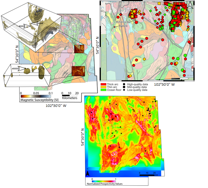
Geology: We present a new geological map under the Phanerozoic cover identifying arc, back-arc, ocean floor, structural domains and post-accretionary assemblages, combining geophysical pattern with lithogeochemistry
Geochemistry: We present a machine learning classifier identifying lithotectonic environments, even with legacy data and without expensive trace-elements concentrations
Geophysics: We present 3D magnetic inversion models, visualizing target geometries under the Phanerozoic cover without expensive drill core data
Prospectivity Map: We present a prospectivity map that integrates several geodata layers (including predicted geological units under cover, structural domains, geochemical classifications, geophysical anomalies, and mineral occurrences), highlighting areas and targets with greater potential to host mineralization
Targets: We present three discrete targets for VMS exploration. None of them have been drill tested. All are conductive bodies associated with discrete positive magnetic anomalies. They are in favourable lithotectonic domains (rifted arc assemblages) and have been visualized with 3D inversion models of magnetic susceptibility. They are in areas open to mineral exploration

You are interested in seeing the complete presentation? -> send me a message